FinnsAway blog – nomad life and travel adventures
Menu
Hiking in Bulgaria: Balkan Mountains in October
Even if we had been in Bulgaria twice before, can’t really say that we knew much about the country. First visit was a week-long package holiday to the coast with our orchestra over ten years ago, so about sun and fun, not that much about traveling. And few years back we made a short, maybe four days long city holiday trip to the capital Sofia, but for some reason that visit didn’t leave any special memories. Maybe the wow-moments were diluted with rainfall, that poured down during that weekend.
This time we headed neither to the Black Sea coast, nor the capital, but to the mountains! Even if Bulgaria may be best known for the sandy beach holidays, huge part of the terrain is actually mountainous and forested. There are seven distinct mountain ranges and the highest peaks rise above 2 900 meters. Bulgaria is an excellent destination not only for hiking and climbing but also for skiing; the oldest ski resort Borovets was founded already back in 1896!
We arrived in the country by car from Romania in the north. Once again we had to cross Donau, which marks hundreds of kilometers of the border of these two countries. Toll for the Giurgiu-Rousse Friendship Bridge was around 3 euros. To be allowed to drive in Bulgaria we also had to buy a vignette, road toll that costs around 8 euros for a week, 16 for a month. In Bulgaria the vignette still was an actual sticker-to-be-attached-to-the-windscreen, instead of electronic toll system.
Hiking in Balkan Mountains
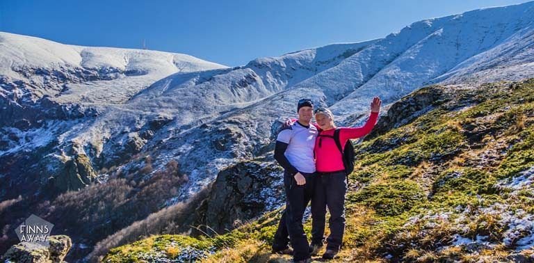
Our first hiking destination was the Balkan Mountain range, also called Stara Planina or Old Mountains, in the middle of the country. This mountain range is no less than 560 kilometers long, and based on the highest peak, it is the third highest range in Bulgaria. The highest peak of Stara Planina range is Mt Botev that reaches 2 376 meters, and somehow we ended up checking hiking options close to this peak.
It is said that this part of Balkan Mountains is especially beautiful, and there are plenty of great options where to start your hike on the northern side of the mountains. We decided to just do shorter day hikes in these mountains, and the small town of Apriltsi seemed suitable base for that purpose. We stayed three days in excellent Balkana Family Hotel, which we can warmly recommend.
We had read that late October is still good time for hiking in Bulgaria, and thus were a bit surprised of the amount of snow that we could see covering the mountains. The view from the Vidima village in Apriltsi was just awesome this time of the year though; autumn colors were in full glow in the valley and the snow-covered Balkanas rise in the background.
Several marked hiking paths can be reached by walking from the village, but if you want to save some time and shorten the approach, driving or hitchhiking closer to mountains is recommended. Our starting point was a parking lot under Pleven mountain hut, basically in the end of Uliska Praskalska road that runs from Vidima village along Starna / Vidima river. Another good starting point for a mountain hike would be in the end of road 607, under hut Tazha.
Our hike to Pleven hut and Vodopada waterfall
We happened to arrive at the Pleven hut parking lot at the same time with a fellow hiker from Bulgaria. So we walked up to the hut together, and he entertained us with some stories about the hiking routes. There are two different routes up from the parking lot, which obviously used to be a sub station for a ski-lift once. Shorter and steeper directly up the slope, and the longer one rounds around along the slope less steeply. We chose the former, and it was a quite sweaty climb of around 400 vertical meters. The path is easy to follow and for the most part even equipped with handrails, but terrain is quite rocky, and with all the fallen leaves hiding the rocks it was a bit challenging to walk.
But still it only took like 45 minutes to reach the Pleven hut. If you are planning a multi-day hike in Balkanas, Pleven is one option to stay a night. Mountain huts in Bulgaria usually cost 5 – 15 EUR per person per night, depending the room type and location. After a short break admiring the mountain views and photographing, we continued up. Original plan had been to hike all the way to the top of Botev peak (around 3 hours from the hut), but after several warnings about the wet conditions we had given up with that, and just wanted to go as high as we safely and easily could. First part was along a ski slope, then the trail dived into a forest. Path was not really snowy, but again full of fallen leaves.
Soon after the forested part ended, we reached a hilltop with awesome views up and down, snow-topped mountains shining in the sun. This was also the spot where the Botev Peak Trail forks to so called summer trail and winter trail. The winter trail, marked with high posts instead of painted trail marks, goes steeply up to Mlechni Chal Peak, and then along the main mountain ridge to Botev. We started to think that it would have been fully possible to go all the way up to the top, since there wasn’t that much snow or mud really. Though the wet snow had already watered our trekking shoes a bit, gore-tex was not enough to keep the moisture out. And to do the full round and get back to the car before dark, we should have started earlier.
So we continued along the lower summer trail, crossed couple of streams and walked past the crossroad of an optional trail back down. We continued until we reached an edge of some kind of canyon or gorge with wonderful waterfall, called Vodopada, rushing down on the opposite side. Perfect place for a lunch break and just watching the beautiful scenery.From here we could already see the weather station that is on top of Botev peak, it would have been just around 500 vertical meters more to reach it. But we headed back down instead, along the steeper optional trail this time, since we wanted to also see Vodnite Dupki Cave with an underground stream.
This part of the hike was the most difficult, at least at this time of the year. The trail goes down steeply, and when reaching the forested part, there is lot of roots and rocks that now were covered with leaves. The soil was also a bit wet and muddy, so it was really hard to get down without slipping. Trekking poles would have helped a bit probably. However, we managed to pass the steep part without bigger accidents, and soon reached the crossroad where another trail goes to the cave. It was actually further away than we thought, but worth the effort.
Vodnite Dupki Cave and back down
Vodnite Dupki (meaning water hall) Cave, is formed in limestone at the foot of the same gorge that we earlier admired from the top. Total length of the cave is 813 meters, but it is still forming. Up to 17 species of bats and bunch of different spiders and insects have been detected there. Also, it is said that sometimes a bear pics this place up for a wintering nest. Unfortunately it is forbidden to enter the cave, so we just peeked in to the entering hall.
To get to the cave, you need to cross the stream that is gushing from the cave, which was somewhat challenging without getting wet. After hiking back to the main path, we took the shortest route back to the parking lot. Total length of the hike was only about 11 km, but it took over 6 hours, which indicates that the terrain was difficult at times, even if the total ascent was not more than 850 vertical meters.
Botev mountain is somewhat infamous for its weather; it can get really foggy, and that happens quickly. We obviously had good luck, since it was a perfectly clear day, not windy at all and sun shined from the blue sky the whole day. But especially during winter hikers should be really careful when up there, we were told that there are casualties every year, as hikers get lost in the fog. So warnings should be taken seriously.
General tips for hiking in the mountains
- have a hiking map, even if the trails are well marked
- don’t risk it in the mountains, check the weather forecast beforehand and don’t overestimate your pace
- for emergencies, have the number of mountain rescue with you (as well as a phone of course)
- stay on the marked paths
- don’t leave any trash behind
- hiking boots are needed, water proof ones are the best bet
- carry warm clothes with long sleeves even if the day is warm and sunny
- it’s good to have waterproof jacket or other cover for rain and wind
- sunscreen and a hat help to protect from the sun
- always carry a torch or a headlight
- take plenty of water, even though you can get it from huts and mountain streams
- food with high calorie content is recommended to keep energy levels up
- keep some cash with you, food and other supplies can be bought from mountain huts
How to get to Apriltsi
If you don’t have your own wheels, don’t worry, you can reach the Balkan mountains also by public transportation. For example, there are couple of operators for a bus route between the capital Sofia and Apriltsi, like Avtogari, that has 5 departures a day. Depending on the operator and route the journey lasts around 3 hours and costs around 10 euros.
In addition to hiking, we also found great paths for trail running in Apriltsi. There are also opportunities for biking, horse-riding, mountaineering and fishing in the middle of beautiful landscape, recommended for all outdoor-enthusiasts!
Gallery
Our resources
and Discounts
and Discounts