Daytrips from Batumi: Machakhela Valley
Batumi is best known as a beach holiday destination, but the surrounding Adjara mountains offer possibilities for much more than sunbathing. There actually even are two national parks very close to Batumi, with some hiking trails on the forested hills above river valleys. There are organized tours available, but it’s also fully possible to arrange day trips by yourself, using public transportation or a rental car. In this post we introduce Machakhela National Park and overall the Machakhela River valley.
Machakhela Gun Road
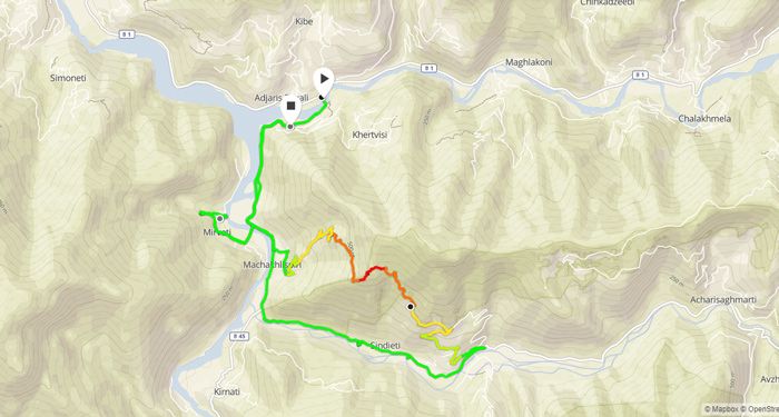
The whole road from Batumi to Zeda Chkhutuneti village has been named as Machakhela Gun Road, but the actual sightseeing route begins from Ajaristskali village, along the Batumi – Keda main road, from where a smaller side road leads to Machakhela valley. The whole length of the Gun Road is 47 kilometers, and the main section from Ajaristskali to Zeda Chkhutuneti is roughly 20 kilometers, so it’s best to travel there either on a rental car, using public transportation or on a tour with a driver. Part of the visitors also cycle all the way to Machakhela from Batumi, but the traffic on the main road is pretty heavy for that.
The name of the Gun Road comes from old gun making traditions in Machakhela River valley. The main sights in the area, however, are beautiful arched stone bridges, waterfalls, ruins of fortresses and the small villages, that offer also accommodation, traditional cuisine and souvenirs for tourists. Regarding the gun manufacturing traditions, there is a Gun Monument by the entrance to the national park, and in Skirdidi village a gun that was used in WWII to control the usage of roads leading deeper in the valley.
To get to Machakhela valley, we took a Keda-bound minibus from Batumi old bus station, and hopped off in Ajaristskali, to walk from there in to the valley. On foot it was only possible to explore the first part of the valley, including Mirveti village and part of the hiking paths in the national park. There are also some minibuses running deeper into the valley, all the way to Zeda Chkhutuneti or Chikuneti villages. In that end of the valley it’s possible to explore on foot sights like Kokoleti Bridge, Chkhutuneti Fortress, as well as Chkhutuneti waterfall and Historical and Ethnographic Museum. For those interested in the old stone bridges, Tskhemlara Bridge near the village by the same name is an especially picturesque option.
Mirveti arch bridge and Waterfall
Mirveti is the first village in Machakhela valley, just three kilometers from Ajaristskali. It’s accessed by crossing the Chorokhi River, along a narrow bridge, and following the dirt road turning right soon after the bridge. Near the tiny village is a small (15 meters long) medieval, arched stone bridge, typical structure for Ajara region. From the parking lot and picnic area, there is a path leading to beautiful Mirveti Waterfall. It’s just few hundred meters through a forest, but almost like walking in a fairyland! The trees next to the path are all covered with thick, dark green moss. Mirveti is outside of the most visited tourist route, and thus a quiet and pleasant site to explore also in high season. In October we only saw a handful of other tourists during the day.
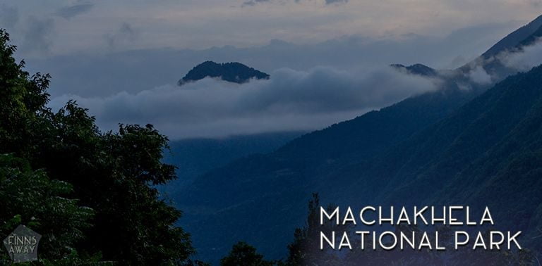
Hiking in Machakhela National Park
Machakhela National Park was founded on the hills above Machakhela river in 2012. 95 % of the park is forested, with interesting flora and fauna. There are some unique relict plants, like Colchis boxwood, chestnut and Colchis and Georgian walnut. Species like deer, wild boar, wolves and jackals live in the forests, as well as protected species like lynx, chamois and even brown bear. We didn’t see any animals though, except for some birds, and a cute dog that came from nowhere and wanted to guide us down from the mountains.
There are two hiking paths in Machachela NP, and the National Park administration center is in Acharisagmarti village. It’s possible to start your hike either form Acharisagmarti, or from along a narrow dirt road that leads to Sindieti village. From both starting points it’s possible to hike up to Archangel Mountain, with views over the valley. As we walked to the park all the way from Ajaristskali village, we started the hike from Sindieti, not visiting the administration center at all.
After walking couple of kilometers up from the road towards Sindieti, there is a map of the hiking trails and the actual starting point of the trail. First part of the path up from Sindieti is quite steep and somewhat rocky, so good hiking shoes are recommended. Otherwise the paths are easy to walk, and the highest point on top of the mountain is only 877 meters above sea level. From the Sindieti trail end, it’s roughly 4 kilometers to Archangel mountain, and another 6,4 km from there to Ajaristskali and the visitor center.
We followed the marked path only until the crossroads with a (nearly overgrown) unmarked path, that leads back to the road in Machakhlispiri near Mirveti. It would have been only 1,8 km from there to the mountain top, but it was already getting dark and we had no idea how to get back to Batumi, so we needed to hurry down from the hills. Following the unmarked path down was not a very pleasant experience, as the vegetation was overgrown and there were quite some stinging nettles and plants with spikes. When finally back on the main road, we started walking back towards Ajaristskali, but soon got a ride from a friendly local family heading to Batumi.
Practical information
It’s possible to visit Machakhela Valley throughout the year, but the nature is at its best from spring to autumn, and the tourist season lasts from May to October. Traditional Machakloba festival is arranged yearly in September, and would for sure be great timing for a visit filled with cultural activities, traditional cuisine and folklore. In the villages there are restaurants and small shops, and also several guesthouses for a bit longer stays.
For more info and leaflets about Machakhela, visit a tourist information office in Batumi, and check out also the GoBatumi websites. Tourist information office can be also useful for checking up-to-date info regarding which minibuses drive all the way to Zeda Chkhutuneti or Chikuneti villages. For hiking in Machakhela National Park, check out the GPS track of our walk (the whole route from Ajaristskali via Mirveti to the national park and back down near Mirveti), and the picture of the hiking map from along the way. We didn’t find any other actual maps of the routes, but I suppose they have some leaflets with maps in the park administration center.